L-A-D Foundation - Land Stewardship in the Missouri Ozark Highlands Since 1962
L-A-D Foundation - Land Stewardship in the Missouri Ozark Highlands Since 1962


Dripping Springs Natural Area, Texas County, 8.59 acres
Description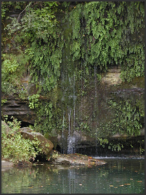
Several springs issuing from the small, north-facing bluff keep the cliff face continually wet. Water emerges from two major sources and numerous minor sources about 20-25 feet above the river. The water tends to drip or weep over the bluff except for the largest source and that becomes a waterfall. Mosses and liverworts are common.
Directions
There is no public access to this small area by land, however, the bluff and springs can be viewed by floaters on the Big Piney River. The Big Piney is known as a fishing stream and is the largest that empties into the Gasconade River. This site is about three miles downriver from the Baptist Camp access.
Recognition
This area was designated a Missouri Natural Area on April 11, 1973 and is leased to the Missouri Department of Conservation for management.
For more information click http://www.mdc.mo.gov/discover-nature/places/natural-areas/dripping-springs
© 2013-2023 L-A-D FOUNDATION ♦ 725 KINGSLAND AVE., SUITE 100, ST. LOUIS, MO 63130 ♦ 314-621-0230 ♦ EMAIL: INFO@LADFOUNDATION.ORG
PIONEER FOREST ♦ PO BOX 497, SALEM, MO 65560 ♦ 573-729-4641
♦ SEE PRIVACY POLICY
This site maintained by Craig Technology Consulting • 201 E. 4th St. • Salem, Missouri 65560 • PH 573.453.2322