L-A-D Foundation - Land Stewardship in the Missouri Ozark Highlands Since 1962
L-A-D Foundation - Land Stewardship in the Missouri Ozark Highlands Since 1962


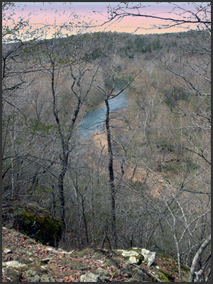
Horseshoe Bend Natural Area, Texas County, 233 acres
 Description
Approximately two miles of the Big Piney River extends around an almost mile-long arm of land which includes a high dolomite bluff along with forests of oak-pine and mixed oak-hickory, as well as mixed bottomland forest. The west-facing bluff in the southern half of the property sits high, offering an impressive view across the Big Piney through some of the largest shortleaf pine here. Along the river are sycamore, silver maple, walnut, and willow. Blankenship Cave is found here, one of several shelters.
There is parking for several cars and a trail leads from there along the high ridge before dropping down to the river.
Recognition
In 1973, a 69-acre area was designated as a Missouri Natural Area. The entire property is leased to the Missouri Department of Conservation for management.
Directions
Travel north through Houston on Grand. Grand becomes Mineral Drive and crosses Brushy Creek. Continue north on Mineral Drive to Horseshoe Drive. Turn left (west) and follow this road as it narrows to a small lane and leads to the small parking area just inside the south boundary.
For more information click http://www.mdc.mo.gov/discover-nature/places/natural-areas/horseshoe-bend
© 2013-2023 L-A-D FOUNDATION ♦ 725 KINGSLAND AVE., SUITE 100, ST. LOUIS, MO 63130 ♦ 314-621-0230 ♦ EMAIL: INFO@LADFOUNDATION.ORG
PIONEER FOREST ♦ PO BOX 497, SALEM, MO 65560 ♦ 573-729-4641
♦ SEE PRIVACY POLICY
This site maintained by Craig Technology Consulting • 201 E. 4th St. • Salem, Missouri 65560 • PH 573.453.2322