L-A-D Foundation - Land Stewardship in the Missouri Ozark Highlands Since 1962
L-A-D Foundation - Land Stewardship in the Missouri Ozark Highlands Since 1962


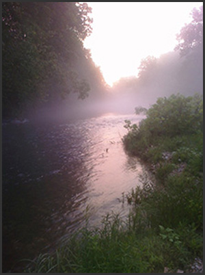
Riverways Corridor Lands (Scenic Easements), Shannon and Carter Counties, 951 acres
 Description
The L-A-D Foundation owns and manages properties governed by permanent scenic easements of the National Park Service, Ozark National Scenic Riverways.
Recognition
Ozark National Scenic Riverways was established by Congress in 1964 and these easements along the river were created in 1970. They were designed to protect the river resource by prohibiting further development, allowing public recreation, ensuring the scenic integrity of the river corridors, and thereby offering an important measure of protection.
Directions
These lands, situated along both the Current and Jacks Fork Rivers, occur along the upper Current both above and below Akers Ferry. Also, below Sinking Creek between river miles 32.5 and 56.0, floaters pass more than 23 miles of Foundation-owned land along one or both sides of the Current River.

Current River in Shannon County, PHOTO BY: Greg Iffrig
© 2013-2023 L-A-D FOUNDATION ♦ 725 KINGSLAND AVE., SUITE 100, ST. LOUIS, MO 63130 ♦ 314-621-0230 ♦ EMAIL: INFO@LADFOUNDATION.ORG
PIONEER FOREST ♦ PO BOX 497, SALEM, MO 65560 ♦ 573-729-4641
♦ SEE PRIVACY POLICY
This site maintained by Craig Technology Consulting • 201 E. 4th St. • Salem, Missouri 65560 • PH 573.453.2322