L-A-D Foundation - Land Stewardship in the Missouri Ozark Highlands Since 1962
L-A-D Foundation - Land Stewardship in the Missouri Ozark Highlands Since 1962


The Roger Pryor Pioneer Backcountry

Jerktail Mountain Ecological Management Area
PHOTO BY: Neal Humke

Roger Pryor Pioneer Backcountry Sign
PHOTO BY: Greg Iffrig

The Roger Pryor Pioneer Backcountry is part of Pioneer Forest, a successful working forest demonstrating a conservative method of forest management where individual trees are selected for harvest. Hiking through the backcountry visitors witness the more than sixty-five years of restoration of thousands of acres of forest and woodland, all while under conservative forest management.
In the fall of 2001, Leo Drey announced that Pioneer Forest's largest block, some 62,000 acres in size, would be dedicated to providing primitive dispersed recreation, and named in honor of Roger Pryor, a friend, advisor, and a leading voice for conservation.
This is an area where motorized vehicles are prohibited beyond the county roads. It is an ideal setting for those who may wish to venture off-trail and walk for miles down an Ozark stream. Explorers and adventure seekers will find this "big woods" is ideal for camping, watching wildlife, listening to nature, and taking pictures.
This backcountry is remarkable for its size and for the experience of wildness that it provides. At 62,000 acres, the Roger Pryor Pioneer Backcountry is the largest contiguous piece of land under any ownership, public or private, in the state of Missouri. Its setting is deep in the Ozark region of southern Missouri, north of the Current River. Visitors seeking primitive recreation in a large and undeveloped landscape will be satisfied.
Beginning near Round Spring, the Backcountry protects a significant portion of the Current River watershed along more than twenty river miles. Some of the Backcountry's river frontage is managed under easement as part of the Ozark National Scenic Riverways, America's first national river park. Miles of trails cross clean and clear Ozark streams following the ridges, hollows, and bluffs of the watersheds of Big Creek, Brushy Creek, and Blair Creek. The landscape here is rugged and remote. It is a karst region with losing streams, caves, and springs and includes an outlier of igneous rock, adding to the diversity of natural communities.
This is a large and primitive area to hike and explore. It includes many miles of river frontage along the Current River, where a multitude of volunteers have worked to construct and maintain trails through the backcountry. It started with the thirteen miles of the Ozark Trail, constructed by volunteers from the Sierra Club during the late 1970s. Other trails follow the picturesque Laxton Hollow and Brushy Creek. There are stunning views of the Current River reached along the more than 60 miles of hand-crafted trails.


PHOTOS BY: Kathie Brennan
The 12-mile Blair Creek Equestrian Trail connects through the backcountry from a trailhead on the Mark Twain National Forest (north) and a trailhead on the current River Conservation Area (south) on Missouri Department of Conservation land. The Sugar Tree Hollow Trail will be under construction soon and allow state park visitors to walk directly out of the park, into the backcountry, and return on the loop trail. The Roger Pryor Pioneer Backcountry provides satisfying day-hiking, more challenging backpacking, or opportunities for cross-country travel and orienteering.
In 2004 Drey authorized the donation of a lease of the Trails of the Roger Pryor Pioneer Backcountry to the Missouri Department of Natural Resources as a recreational component of Missouri's State Park System.

Big Creek, shown here, is one of three small, clear water streams in the Backcountry that feed the Current River
PHOTO BY: Greg Iffrig
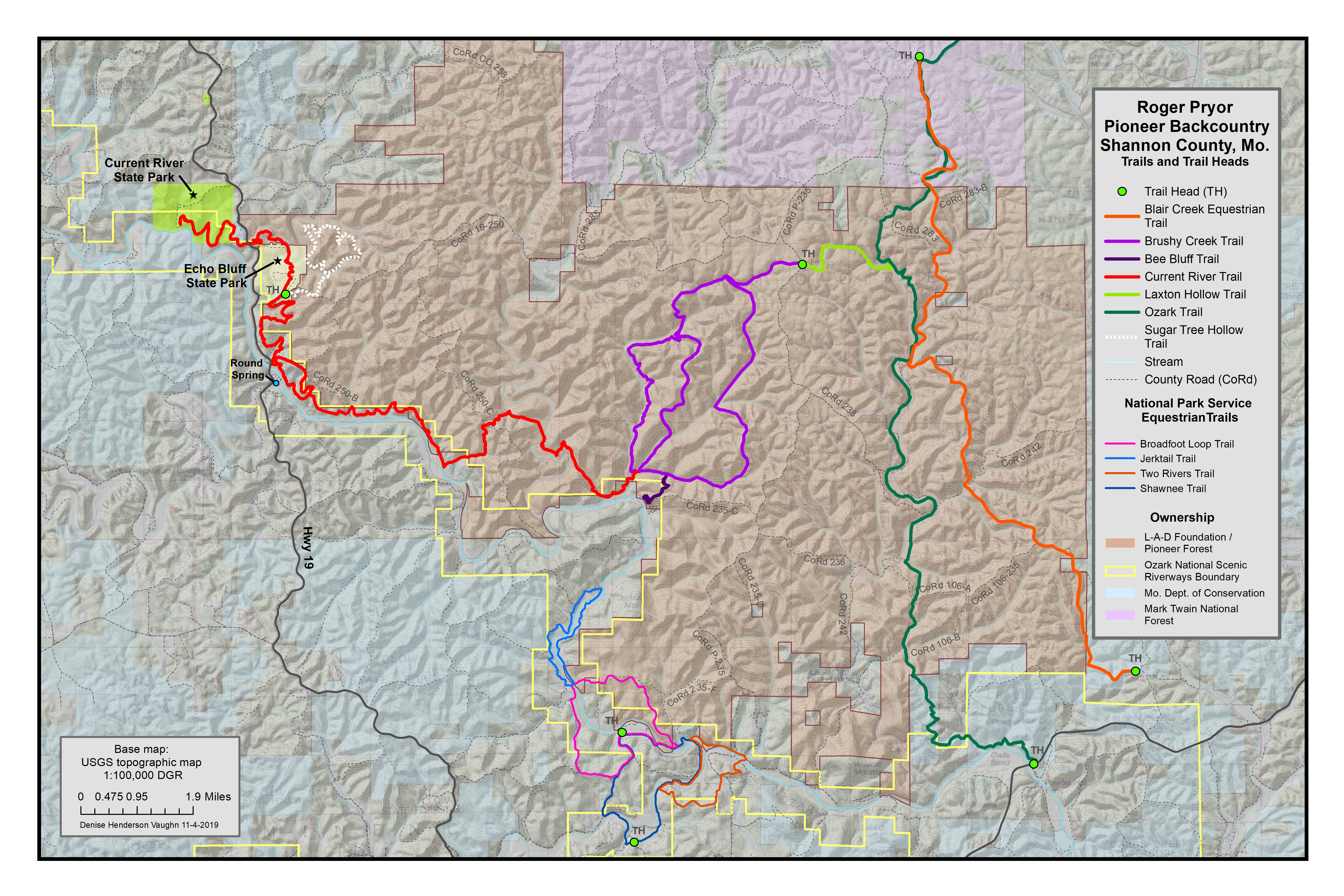
Trails of the Roger Pryor Pioneer Backcountry
Trails are described in alphabetical order below. In the final section of this page, you will find colored maps showing the trails.
Bee Bluff Trail
Map Color: Dark Purple
Distance: 1.9 mile loop
Access: From the Brushy Creek Trail
Returning on the eastern arm of the Brushy Creek Trail from Current River, the junction with the Bee Bluff Spur is less than a mile up Satterfield Hollow and climbs out of the hollow to an expansive overlook of the Current River, affording long views upriver for nearly two miles.
Ozark Riverways lands are located along the river, Pioneer lands including Top Mountain are to the south and its Roger Pryor Pioneer Backcountry is located all along the north side of the Current River.

Lunch Break on Bee Bluff
PHOTO BY: Bob Gestel
Blair Creek Section of the Ozark Trail
Map Color: Green
Distance: 12.5 miles, one-way
Access: Himont Trailhead

PHOTO BY: Bob Gestel
This 12.5 miles of the 26.2-mile-long Blair Creek Section of the Ozark Trail was the first hiking trail to be constructed on Pioneer Forest. It was built with hand tools and completed in the late 1970's. It was also one of the first sections of the Ozark Trail to be completed. In 2008, the Ozark Trail was designated by the US Department of Agriculture as a unit of the National Trails System.
This is a recovering landscape. Hikers on this trail through the Backcountry will encounter remnants of cemeteries, foundations, home places, spring houses, and root cellars. South from the Mark Twain National Forest, the trail crosses the upper reaches of Barton Hollow and Shannon County road CRD 283 leading west to Laxton Hollow. The trail follows along the east side of Laxton Hollow. Laxton Hollow Trail and Laxton Spring are just to the west. Beaver maintain an impoundment where the valley widens and the flat bottom near the spring can be a relaxing spot for lunch or as an overnight camp. The trail continues south for another mile-and-a-half along the west flank of Cedar Point ridge, Cedar Point School was once located near the southern terminus of this long ridge. At this point the trail is near the juncture of Laxton Hollow and Blair Creek where it crosses to the west side of Blair Creek continuing past one of the larger springs McIntyre Spring (formerly Harper Spring) where you may still see the remains of an old spring house near the mouth of Jims Creek. The trail continues downstream following Blair Creek passing Spring Hollow on the east side of the valley before the trail merges with Shannon County CRD 283. From here the trail and the county road are one. Hikers pass Blairs Creek Cemetery, which is still in use, and a road junction. Just beyond, the trail turns abruptly into a small reverting field before it begins climbing the south side of Holmes Hollow. Watch the trail, it crosses just above Holmes Hollow Cave. The trail then turns south, leading up the ridge to cross into Little Blair Creek. Across the creek and after just a half-mile, the trail then crosses from the Roger Pryor Pioneer Backcountry to Bloom Creek State Forest.
The trail makes its way to the bluffs high above the Current River and to outstanding views of the expansive forest and woodlands along the river. This section of the long-distance Ozark Trail finishes at Highway 106. There is a trailhead south of the highway near Owls Bend, part of the Ozark National Scenic Riverways.


THREE PHOTOS ABOVE BY: Rick Thom
Blair Creek Equestrian Trail
Map Color: Orange
Distance: 11.7 miles, one-way
Access: There are two staging areas, one to the north on the Mark Twain National Forest, just off CR 235 (3 miles north of Pioneer Forest), and one to the south on Missouri Department of Conservation Rocky Creek Conservation Area, on Shannon County CRD 106-235 (about a mile north of Highway 106).


Blair Creek Equestrian Trail.
PHOTO COURTESY: Backcountry
Horsemen of Missouri
Other sections of the Ozark Trail are open for horse use, but the original Blair Creek Section of the Ozark Trail across the privately-owned Pioneer Forest was designed for pedestrians and remains hiking only. L-A-D Foundation and Pioneer Forest work with Backcountry Horsemen of Missouri to provide this equestrian route across the backcountry.
The Blair Creek Equestrian Trail was developed as a separate route, following the north-south orientation of the Ozark Trail. The trail extends long-standing equestrian travel on the Mark Twain National Forest further south across Pioneer Forest all the way to Highway 106. A trailhead, which has a turnaround and can accommodate parking for trailers, is available on the Mark Twain National Forest to the north of the Backcountry. Another trailhead is available south of the Backcountry on Rocky Creek Conservation Area.
Brushy Creek Trail
Map Color: Purple
Distance: 15.9-mile exterior loop; with a 3.6-mile interior connector, and a 1.9-mile spur to Bee Bluff.
Access: Himont Trailhead

PHOTO BY: Scott Merritt

PHOTO BY: Greg Iffrig
The Brushy Creek Trail explores the heart of the Backcountry. Its 15.9-mile long exterior loop begins across from the Himont Trailhead, following the flat Polk Ridge for less than a mile before heading into the upper reach of Brushy Creek. The trail follows a long-abandoned 1890’s-era narrow-gauge rail line, its smooth, wide bed makes for pleasant walking through native shortleaf pine. This rail line was a narrow, short spur used for moving oak and pine timber out to larger railroads nearby. Further down the valley, hikers pass the abandoned company town of Brushy where some of the remains may still be visible. The trail follows through the valley as hikers cross into National Park Service land where Brushy Creek empties into the Current River. Here there is an old deer camp and a scenic spot for an overnight stay. Hikers on the main trail continue going up Satterfield Hollow to explore this tributary to Brushy Creek and part of the Current River Natural Area.
The natural area has some of the oldest white oak trees in Missouri, many aged at 400 years and measuring more than 30 inches in diameter. From the natural area the trail route leads up the ridge, around the upper end of Turkey Pen Hollow, then winding down into Middle Prong Hollow. Two miles up the hollow the trail crosses over to reach the main stem of the trail leading out of Brushy Creek. It is a short walk up to Polk Ridge then back to the Himont Trailhead. The other option for hiking is to follow the shorter 3.6-mile long interior connector route which climbs the ridge between Brushy Creek and Middle Prong. This ridgetop trail continues following the ridge north-northeast for three miles before descending into Brushy Creek and joining the main trail.
Current River Trail

PHOTO BY: Kathie Brennan

Current River at mouth of Cabin Hollow, PHOTO BY: Greg Iffrig
Map Color: Red
Distance: 19.5 miles across Pioneer Forest, Ozark National Scenic Riverways, and Missouri State Parks land
Access: From the Brushy Creek Trail, Round Spring trailhead, Echo Bluff State Park, and Current River State Park
The Current River Trail was conceived in 2008 as a long-distance hiking trail, much of it following the river valley and connecting with other trails. The Current River Valley, viewed from this trail, is one of Missouri's most inspiring landscapes. Along the way are sweeping vistas from high above the river, short walks along the river, explorations of tributary streams and their side hollows, as well as climbs up and down the river hills.
This is the region's newest trail. On its west side visitors to Current River and Echo Bluff state parks and the Ozark National Scenic Riverways may enjoy day hikes between parks. The trail begins at the gym for the historic 1930's Alton Box Board Company corporate retreat at Current River State Park. The routing easily climbs the steep hollows along the river to cross Highway 19 then leading to Echo Bluff State Park. Within the park it uses the Wheeler Bridge to cross Sinking Creek and provides access to much of the park. Visitors may also hike from Echo Bluff to Round Spring. Current River Trail includes a 2.5-mile loop at Round Spring.
The main stem of Current River Trail is eleven miles between Round Spring and the mouth of Brushy Creek. Via the Brushy Creek and Laxton Hollow trails its connection to the Ozark Trail opens multiple opportunities for primitive non-motorized recreation including long-distance backpacking north to the Meramec River, east to the St. Francois Mountains, or south and west to the Eleven Point River. This is a gateway trail within the Current River watershed where the adventurous could combine overland hiking with river travel. For example, a 40-mile backpacking trip from Powder Mill to Round Spring could be combined with the 25-mile long water trail return down the Current River. Someday there may the possibility of extending further toward Pulltite and even Montauk State Park.

Laxton Hollow Trail
Map Color: Lime Green
Distance: 2.3 miles, one-way
Access: Himont Trailhead


Laxton Hollow Trail begins just behind the bulletin board at the main trailhead. Laxton Hollow drains from the Polk Ridge and, although only about three miles in length itself, has several nearly mile-long tributary hollows. This trail heads out on Polk Ridge but quickly winds down and around one of the side hollows, taking walkers or hikers three-fourths of a mile along a moss-covered path before reaching the main hollow and its dry gravel creek bed. The trail then follows Laxton Hollow with tall hickory and mature oak trees along the slopes. At Laxton Spring, beaver have maintained a dam creating a clear, shallow pool. From there, the trail crosses Laxton Hollow to join the Blair Creek Section of the Ozark Trail.
This short and scenic trail is great for a day hike; it is also a perfect route for reaching the Ozark Trail and heading south to Owls Bend.
Sugar Tree Hollow Trail (Under Development)
Map Color: Dotted White
Distance: 6.6 miles
Access: Echo Bluff State Park

The trailhead just off Camp Zoe Road at the southern entrance to Echo Bluff State Park will provide parking and access for this hiking-only trail. It has been designed to head northeast into Sugar Tree Hollow. Once across the hollow the trail forms a large loop that can be hiked in either direction.
The western portion of this trail is high above Sinking Creek with the state park below and affording a nice view of the valley when the leaves are off the trees. The northern portion winds along a richly forested north-facing slope. On the southeastern portion of this trail old shortleaf pine stumps can be found from the industrial logging era of the early 1900's. Sugar Tree Hollow is named on topographic maps, likely named for the sugar maple trees that can be found here.
National Park Service Equestrian Trails
These trails cross small pieces of Pioneer Forest or follow county roads crossing the forest:
- Broadfoot Loop Trail, 9 miles, accessed from the Broadfoot Staging Area.
- Jerktail Loop Trail, 2 miles, accessed from the Broadfoot Staging Area.
- Two Rivers Loop Trail, 4 miles, accessed from the Broadfoot Staging Area.
- Shawnee Loop Trail, 7 miles, accessed from the Shawnee Staging Area.
For more information, see the Ozark National Scenic Riverways hiking page.
More information on each of these trails, and others, can be found on the National Geographic, Ozark National Scenic Riverways Outdoor Recreation Map, 2007. Contact National Geographic Maps, P.O. Box 4357, Evergreen, CO 80437-4357; telephone 800-962-1643 or 303-670-3457; or the website www.trailsillustrated.com.
Maps of Trails in Roger Pryor Pioneer Backcountry

To view a full-size version of the above map (12 by 18 inches), click the link and allow time for download. You may then right click if you wish to save the map for printing or future use.
More Detailed Maps of the Trail System Overlaid on 1:24,000 Topo Maps
We have prepared township and range-level maps that show the trails overlaid on a USGS 1:24,000 topo map. View these maps below, or to save or print the map in a higher resolution version, please click the link below the map.
The township maps below outline the Roger Pryor Pioneer Backcountry in yellow and outline Ozark National Scenic Riverways ownership and easements in green. The township maps shade the Roger Pryor Pioneer Backcountry in gray and the Ozark National Scenic Riverways in a more pinkish or brownish color.
The trails are shown in the same color on the overview map and the township maps.
")
Northwest Section (T30N, R4W), Current River Trail
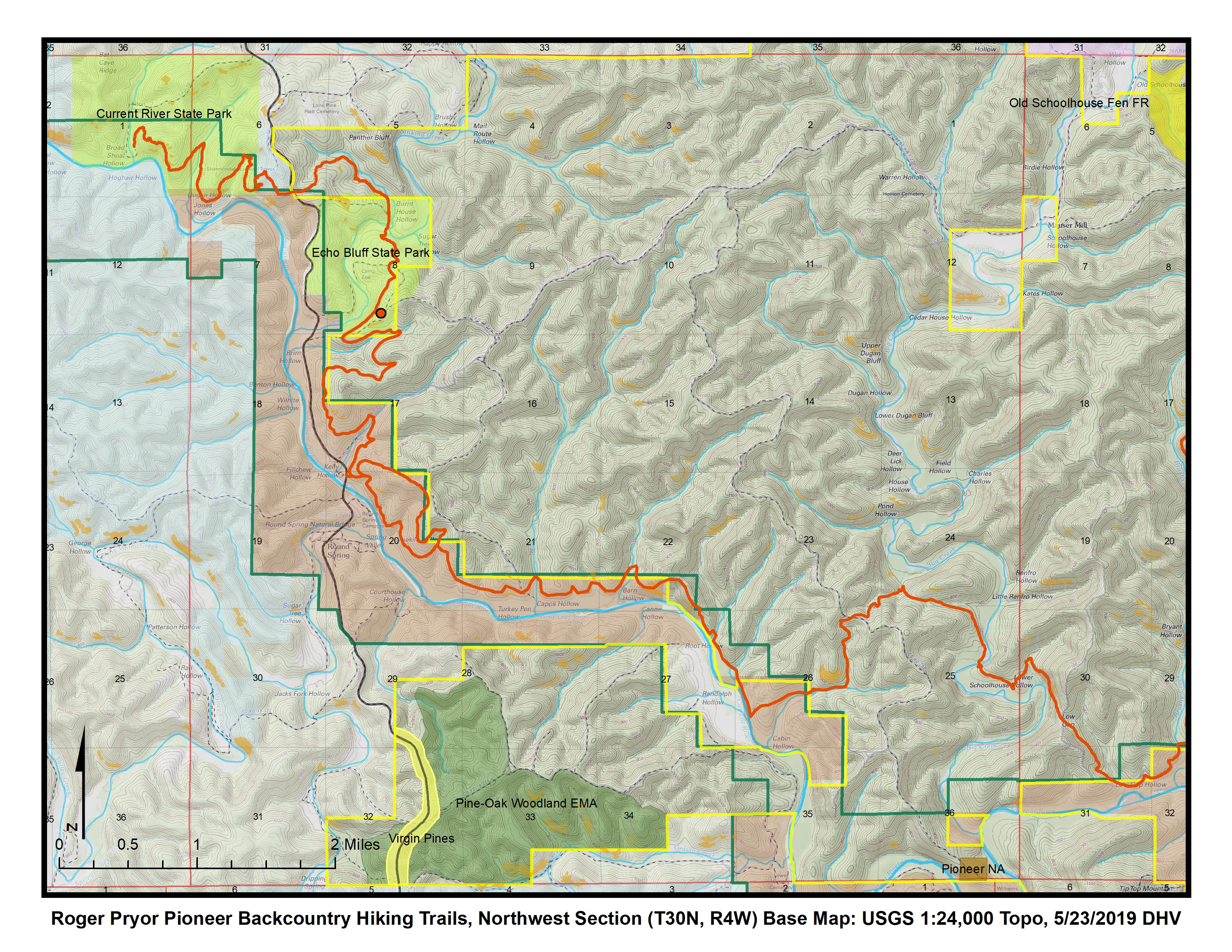
")
North Central Section (T30N, R3W), Brushy Creek Trail, Bee Bluff Trail, portions of Current River Trail, Ozark Trail, and Blair Creek Equestrian Trail
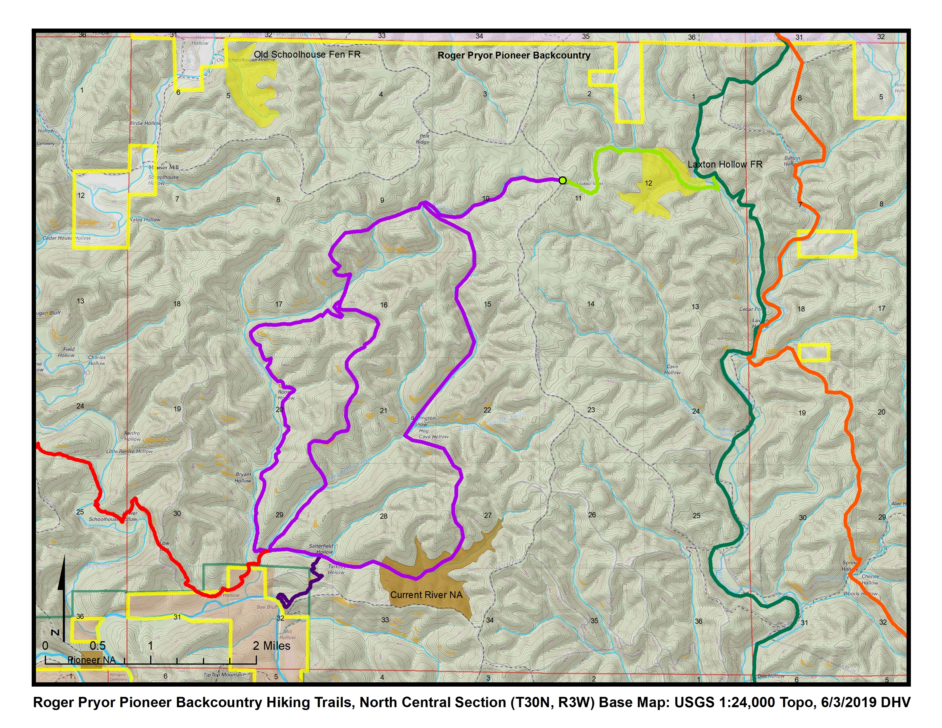

Northeast Section (T30N, R2W), Laxton Hollow Trail and portions of the Ozark Trail and the Blair Creek Equestrian Trail
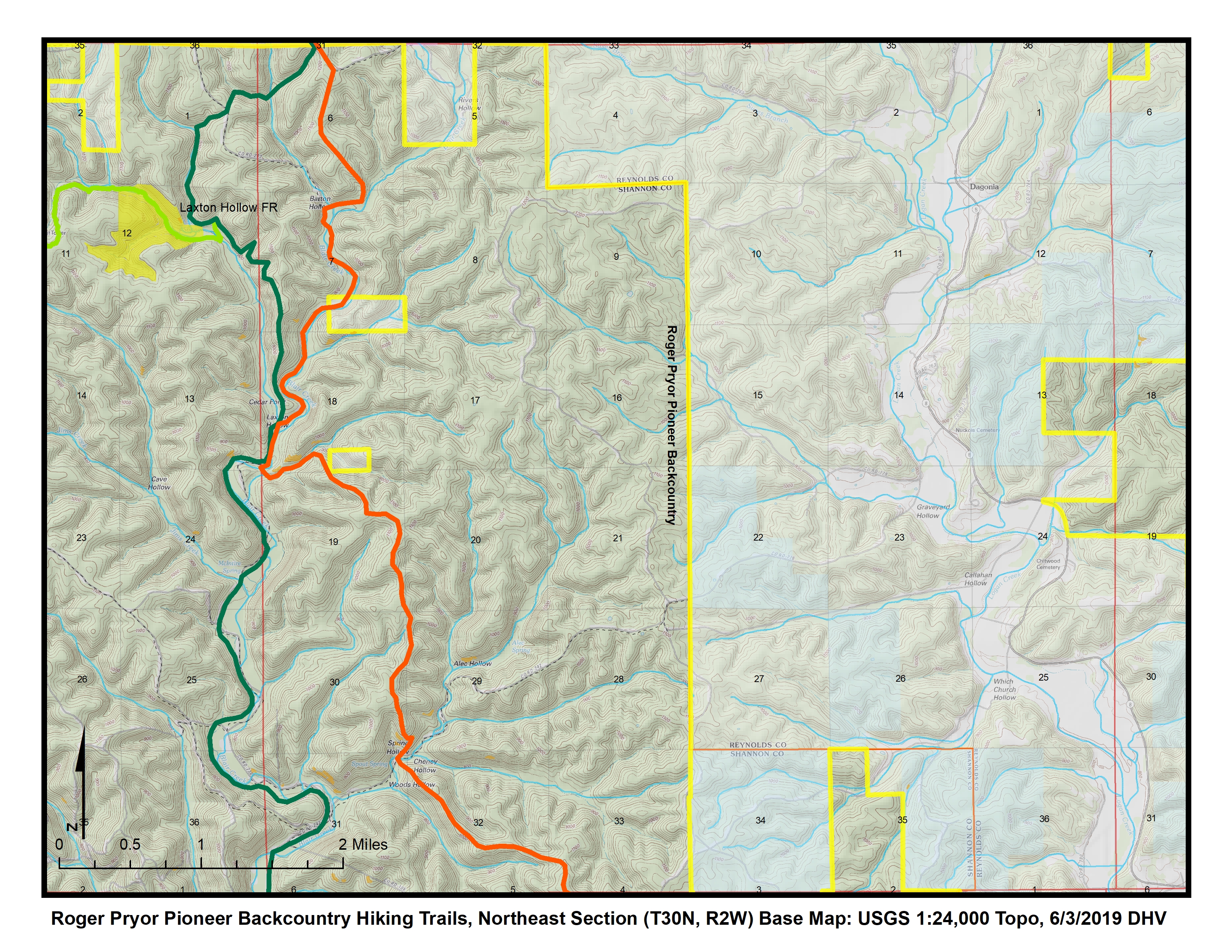

South Central Section (T29N, R3W), National Park Service Equestrian Trails and portion of Ozark Trail

Southeast Section (T29N, R2W), portions of Ozark Trail and Blair Creek Equestrian Trail
© 2013-2023 L-A-D FOUNDATION ♦ 725 KINGSLAND AVE., SUITE 100, ST. LOUIS, MO 63130 ♦ 314-621-0230 ♦ EMAIL: INFO@LADFOUNDATION.ORG
PIONEER FOREST ♦ PO BOX 497, SALEM, MO 65560 ♦ 573-729-4641
♦ SEE PRIVACY POLICY
This site maintained by Craig Technology Consulting • 201 E. 4th St. • Salem, Missouri 65560 • PH 573.453.2322